


Mô tả của PeakLens
PeakLens will transform your mountain activity into an amazing experience, allowing you to get a deeper knowledge of the mountains and to create stunning photos enriched with the most accurate information about the peaks in view.
Discover the names and locations of mountain and hills around you while hiking, climbing, skiing, trekking or enjoying your favorite outdoor activity. Test your mountain knowledge and share your pictures of stunning skyline views with your friends on social networks.
FEATURES
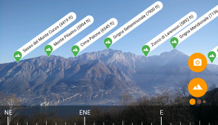
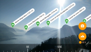
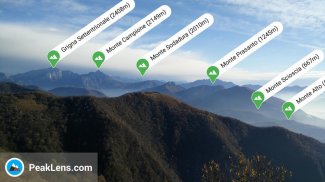
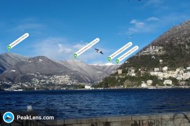
- Precisely identifies mountain peaks and hills in real-time.
- Works worldwide: from Alps, Himalayas, Rocky Mountains and Andes up to the smallest hills, anywhere on Earth.
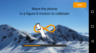
- Corrects GPS, compass, magnetometer and gyroscope errors with artificial intelligence.
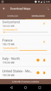
- Works online and offline with pre-downloaded maps.
- High quality photographs with peak names in overlay.
- Knows position, height and distance from you of more than 200.000 peaks.
- Works both with Imperial and Metric unit systems.
PeakLens is a novel Augmented Reality and Virtual Reality app for mountain lovers, hikers and trekkers. It is the result of years of research in artificial intelligence and computer vision, based on a novel algorithm that identifies mountain peaks in real time with high precision. Its core is a software component that compares what you actually see in the camera of your mobile phone or tablet with a virtual panorama, created from a digital 3D landscape model of the Earth. By matching what you see and the virtual panorama, PeakLens automatically corrects most errors that come from the imprecision of the compass and GPS sensor, giving you always the most accurate peak positioning.
RESOURCES
- Digital Elevation Model: the digital elevation model of the SRTM project (https://www2.jpl.nasa.gov/srtm) is used for calculating panoramic views.
- Peaks: the Peaks dataset is extracted from Openstreetmap.com.
OpenStreetMap is open data, licensed under the Open Data Commons Open Database License (ODbL).
PeakLens is a research result of Politecnico di Milano, Dipartimento di Elettronica, Informatica e Bioingegneria.
For any comments, questions or feedbacks contact us at info@peaklens.com!
PeakLens sẽ làm thay đổi hoạt động núi của bạn thành một kinh nghiệm tuyệt vời, cho phép bạn để có được một kiến thức sâu sắc hơn về những ngọn núi và để tạo ra hình ảnh tuyệt đẹp được làm giàu với các thông tin chính xác nhất về các đỉnh núi trong quan điểm.
Khám phá các tên và vị trí của núi đồi xung quanh bạn trong khi đi bộ đường dài, leo núi, trượt tuyết, leo núi hay thưởng thức các hoạt động ngoài trời yêu thích của bạn. Kiểm tra kiến thức núi của bạn và chia sẻ hình ảnh của bạn quan điểm đường chân trời tuyệt đẹp với bạn bè trên mạng xã hội.
TÍNH NĂNG, ĐẶC ĐIỂM
- Chính xác xác định đỉnh núi và đồi trong thời gian thực.
- Làm việc trên toàn thế giới: từ dãy Alps, Himalayas, Rocky Mountains và dãy núi Andes đến những ngọn đồi nhỏ, bất cứ nơi nào trên trái đất.
- Sửa GPS, la bàn, con quay hồi chuyển từ kế và lỗi với trí tuệ nhân tạo.
- Làm việc online và offline với các bản đồ trước khi tải về.
- hình ảnh chất lượng cao với những cái tên đỉnh cao trong lớp phủ.
- Biết vị trí, chiều cao và khoảng cách từ bạn của hơn 200.000 đỉnh.
- Làm việc cả với các hệ thống đơn vị Imperial và Metric.
PeakLens là một cuốn tiểu thuyết Augmented Reality và ứng dụng thực tế ảo cho những người yêu núi, đi bộ đường dài và leo núi. Nó là kết quả của nhiều năm nghiên cứu về trí thông minh và máy tính tầm nhìn nhân tạo, dựa trên một thuật toán mới để xác định đỉnh núi trong thời gian thực với độ chính xác cao. cốt lõi của nó là một thành phần phần mềm so sánh những gì bạn thực sự thấy trong máy ảnh của điện thoại di động hoặc máy tính bảng của bạn với một bức tranh toàn cảnh ảo, được tạo ra từ một mô hình cảnh quan 3D kỹ thuật số của Trái Đất. Bằng cách kết hợp những gì bạn nhìn thấy và bức tranh toàn cảnh ảo, PeakLens tự động sửa chữa hầu hết các lỗi đó xuất phát từ sự thiếu chính xác của cảm biến la bàn và GPS, giúp bạn luôn vị trí đỉnh cao chính xác nhất.
TÀI NGUYÊN
- Digital Elevation mẫu: mô hình độ cao số của dự án SRTM (https://www2.jpl.nasa.gov/srtm) được sử dụng để tính toán tầm nhìn toàn cảnh.
- Peaks: dataset Peaks được chiết xuất từ Openstreetmap.com.
OpenStreetMap là dữ liệu mở, cấp phép theo dữ liệu mở Commons Open Database Giấy phép (ODbL).
PeakLens là kết quả nghiên cứu của Politecnico di Milano, Dipartimento di Elettronica, Informatica e Bioingegneria.
Đối với bất kỳ ý kiến, thắc mắc hoặc phản hồi liên hệ với chúng tôi tại info@peaklens.com!
PeakLens - Phiên bản 2.0.8
(03-11-2023)PeakLens - Thông tin APK
Phiên bản APK: 2.0.8Gói: com.peaklens.arỨng dụng cùng danh mục
Bạn cũng có thể thích...


